Category

Weather Companies

9 organizations3 countries

9 organizations working in weather across the global space industry.

Names to know in weather

Rank all by market value →
Earth Observation Verified

GeoOptics

Pasadena, United States commercial

GeoOptics is a Pasadena, California-based commercial weather data company founded in 2006 that operates the CICERO (Community Initiative for Continuous Earth Remote Observation) satellite constellation, collecting GNSS radio occultation (GNSS-RO) atmospheric profiles for operational weather forecasting, climate research, and space weather monitoring. GeoOptics was one of the first commercial companies to develop a business model around selling GPS radio occultation data to government meteorological agencies, pioneering the commercial weather data market that NOAA's Commercial Weather Data Pilot program subsequently formalized. CICERO satellites use multi-frequency GNSS receivers to track signal bending from GPS, GLONASS, Galileo, and BeiDou constellations as they set and rise behind Earth's limb, producing vertical temperature and moisture profiles from approximately 50 km altitude down to within 1 km of the surface. These profiles have 100–200 m vertical resolution in the troposphere — finer than conventional radiosonde balloons — and are globally distributed without geographic gaps, making them particularly valuable over oceans and the Southern Hemisphere where conventional sounding networks are sparse. GeoOptics secured contracts under NOAA's Commercial Weather Data Pilot (CWDP) program in 2016 — the first cohort of commercial RO data vendors — alongside Spire Global and Stellar (now PlanetIQ). NOAA subsequently evaluated the commercial data's impact on forecast skill and determined it provided measurable positive impact when assimilated into operational models, leading to expanded commercial procurement programs. GeoOptics delivers CICERO data to NOAA's NCEP (National Centers for Environmental Prediction) for assimilation into the Global Forecast System (GFS) and other operational forecast models. Beyond tropospheric meteorology, CICERO's high-altitude occultations provide ionospheric electron density profiles for space weather research and GPS navigation error correction services. GeoOptics competes primarily with Spire Global — the dominant commercial RO provider by constellation size and occultation count — and PlanetIQ in the commercial GNSS-RO data market.
Pasadena, United States · Est. 2006
Ground Systems Verified

ISTRAC

Bangalore, India government

ISTRAC (established 1984 and located in Bangalore, India) is a critical component of the Indian Space Research Organisation (ISRO), functioning as its dedicated telemetry, tracking, and command (TT&C) network. The organization designs, develops, and maintains a global network of ground stations essential for supporting both low-Earth orbit and interplanetary missions. This infrastructure provides vital communication links for spacecraft operations, encompassing launch vehicle missions and the Indian Regional Navigation Satellite System (IRNSS). ISTRAC’s core capabilities center around ground-based systems, specifically the design and implementation of TT&C infrastructure. This includes not only the physical ground stations but also the associated software and expertise required for reliable communication and control of space assets. Notably, ISTRAC operates a deep space network specifically tailored to support India’s ambitious lunar and Mars missions, demonstrating a capacity for complex, long-distance spacecraft communication. Beyond its primary role in space missions, ISTRAC also diversifies into terrestrial applications. The organization designs and develops weather radars and provides search and rescue facilities, leveraging its expertise in signal processing and communication technologies for broader societal benefit. ISTRAC’s position within ISRO and its specialized focus on ground systems establish it as a foundational element of India’s space program. It doesn’t compete in launch services or satellite manufacturing, but rather provides the essential infrastructure that *enables* those activities, and increasingly, contributes to terrestrial monitoring and safety applications.

Bangalore, India · Est. 1984
Earth Observation

PlanetIQ

Golden, United States commercial

PlanetIQ is a Golden, Colorado-based commercial weather data company founded in 2016 that operates a constellation of small satellites to collect GPS radio occultation (GNSS-RO) measurements for improving numerical weather prediction accuracy. Radio occultation works by measuring how GNSS signals from GPS, GLONASS, Galileo, and BeiDou satellites bend as they pass through Earth's atmosphere at different tangent altitudes — these bending angles are processed into vertical profiles of temperature, pressure, and moisture with approximately 200 m vertical resolution, covering all latitudes and all weather conditions regardless of cloud cover or precipitation. GNSS-RO data is uniquely valuable to operational meteorology because it requires no calibration from external reference, is unaffected by clouds or rain that block passive infrared sounders, and provides global coverage with no gaps. Assimilating RO data into weather forecast models measurably reduces forecast errors — studies show 5–12% improvement in 3-day forecast skill for mid-latitude systems. NOAA's COSMIC-2 constellation demonstrated the value of operational RO at scale, and PlanetIQ targets providing commercial augmentation to NOAA, EUMETSAT, and the private weather modeling market. PlanetIQ's GNOMES satellite constellation (GNSS Navigation Occultation and Meteorological Experiment Satellites) uses miniaturized RO receivers compatible with 6U CubeSat platforms, dramatically reducing the cost per occultation measurement compared to earlier-generation COSMIC/COSMIC-2 heritage spacecraft. The company secured NOAA contracts under the Commercial Weather Data Pilot and follow-on programs to deliver RO profiles into NOAA's Global Forecast System and other operational models. PlanetIQ competes in the commercial GNSS-RO market primarily with Spire Global (the dominant commercial RO data provider with 100+ satellites delivering millions of soundings per day) and GeoOptics. PlanetIQ differentiates on data quality per observation and specialized capabilities including dual-frequency ionospheric correction and rising occultation geometry optimization.

Golden, United States · Est. 2016
Earth Observation

Spire Weather

Vienna, United States commercial

Spire Weather, founded in 2012 and based in Vienna, United States, is a data and analytics company specializing in satellite-based weather forecasting. The company utilizes a constellation of low-Earth orbit nanosatellites and advanced radio occultation (RO) technology to gather precise atmospheric measurements globally. This data is then processed into actionable Earth Intelligence, providing businesses with enhanced weather predictions and insights. Spire Weather offers a suite of tailored solutions including DeepInsights™, a comprehensive forecasting and data visualization tool; DeepVision™, a monitoring application for both fixed and moving assets; and Deep Navigation Analytics™, a weather intelligence platform focused on maritime applications. These solutions cater to a diverse range of industries including utilities, supply chain, commodity trading, maritime, and agriculture/insurance, offering services such as optimized route planning, asset monitoring, and predictive analytics powered by artificial intelligence and machine learning. While specific customer details are limited, testimonials highlight the company’s data volume, flexibility, and support, with a focus on improving accuracy in open ocean forecasting and enabling sustainable practices. Spire Weather positions itself as a provider of critical data for minimizing weather-related risks, optimizing operations, and driving informed decision-making across various sectors.

Vienna, United States · Est. 2012
Earth Observation Verified

Tomorrow.io

Boston, Massachusetts, United States commercial

Tomorrow.io (originally founded as ClimaCell in 2016 by Shimon Elkabetz, Rei Goffer, and Itai Zlotnik) is a Boston-headquartered weather intelligence and space-weather company. It operates a proprietary global weather-forecast platform and in 2023–2024 began launching a constellation of Ku-band precipitation radar and microwave-sounder satellites intended to fill coverage gaps left by aging government weather satellites. The first Tomorrow.io pathfinder satellites (Tomorrow-R1 and R2) launched on Rocket Lab Electron missions in 2024, demonstrating space-based precipitation radar from a small commercial platform — a capability previously only operated by government-led missions such as NASA/JAXA's GPM. Data from the constellation feeds into Tomorrow.io's commercial forecasting API used by airlines, logistics, insurance, agriculture, and public-sector customers. Investors include Koch Disruptive Technologies, SoftBank, Canaan Partners, JetBlue Ventures, and Pitango. The company has signaled ambitions to deploy dozens of radar and sounder satellites by the late 2020s. Tomorrow.io is representative of a new class of commercial weather operators challenging government-only Earth-observation weather data pipelines.

Boston, Massachusetts, United States · Est. 2016
Research

University Corporation for Atmospheric Research

Boulder, United States consortium

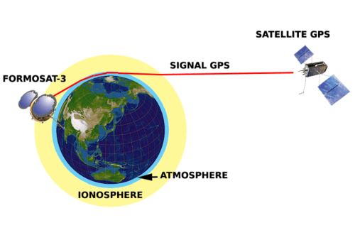
The University Corporation for Atmospheric Research (UCAR) is a US nonprofit consortium of universities, established in 1959 by faculty from 14 institutions and incorporated in 1960, headquartered in Boulder, Colorado. It now comprises more than 120 North American member universities plus dozens of international affiliates engaged in atmospheric and Earth-system science. UCAR's founding purpose, and its principal ongoing role, is managing NSF NCAR (the National Center for Atmospheric Research) on behalf of the US National Science Foundation, which remains its primary sponsor; UCAR also receives funding and contracts from NOAA, NASA, the Department of Defense/US Space Force, the FAA, DOE and EPA, with total fiscal-year expenditures of roughly $311 million in FY2024. UCAR manages the COSMIC GNSS radio-occultation satellite program in partnership with Taiwan's space agency. The original six-satellite COSMIC-1 constellation (also called FORMOSAT-3), built with Taiwan's National Space Organization (NSPO), launched in April 2006 and operated until roughly 2020, demonstrating that GPS radio-occultation soundings measurably improved numerical weather forecasts. Its successor, COSMIC-2 (FORMOSAT-7) — a six-satellite constellation again built with NSPO, which was reorganized and renamed the Taiwan Space Agency (TASA) in 2023 — launched aboard a SpaceX Falcon Heavy on 25 June 2019 and reached full operational capability in October 2021; as of early 2026 all six satellites remained operational, together producing several thousand atmospheric and ionospheric soundings daily. UCAR distributes this data worldwide, free of charge, through its COSMIC Data Analysis and Archive Center (CDAAC), and dozens of national weather services assimilate it operationally. Beyond COSMIC, UCAR's space-related work traces back to the 1995 GPS/MET proof-of-concept mission and extends, through NCAR and UCAR's community programs, into satellite data assimilation, space-weather research, and Earth-observation instrument and mission support for NASA and NOAA. Antonio J. Busalacchi Jr. has served as UCAR's president since August 2016.

Boulder, United States · Est. 1960
Weather In development

Earththunder

Melbourne, Australia commercial

Earththunder is a Melbourne, Australia-based space startup founded in 2022 developing a constellation of LEO microsatellites equipped with optical lightning detection sensors for real-time global thunderstorm monitoring. Traditional lightning detection relies on a sparse network of ground-based sensors (such as Vaisala's GLD360) that provide good coverage in developed regions but leave large ocean areas and developing-world landmasses poorly monitored. A LEO constellation overcomes this limitation, providing near-continuous global detection latency measured in minutes rather than hours. Real-time lightning mapping has direct commercial value for aviation (route optimization, severe weather avoidance), insurance underwriting, agriculture, utilities (wildfire ignition risk), and emergency services. Earththunder competes in a nascent niche that also includes NASA's GOES-R Geostationary Lightning Mapper (GLM) — which is fixed in GEO — and proposed commercial constellations. The company is in development, backed by the Australian Space Agency's Moon to Mars Initiative and the broader NewSpace ecosystem centered in the Asia-Pacific region.

Melbourne, Australia · Est. 2022
Earth Observation In development

Windborne Systems

Palo Alto, United States commercial

Windborne Systems, founded in 2019 and based in Palo Alto, California, is a space-focused company specializing in enhanced atmospheric data collection for improved weather forecasting. The company designs, builds, and operates a constellation of long-duration, smart weather balloons. These balloons are intended to gather critical data points within the atmosphere, supplementing existing weather observation systems. Windborne’s core offering centers around this balloon constellation and the data it provides. While specific technological details are limited in publicly available information, the focus on “long-duration” balloons suggests a key capability lies in extending the lifespan and data-gathering potential of traditional weather balloons. This likely involves advancements in balloon materials, power systems, and data transmission technologies to maintain operational functionality for extended periods. Currently focused on the earth-observation and weather sectors, Windborne aims to deliver more accurate and timely weather forecasts. While specific missions or customer details haven't been publicly released, the company positions itself as a provider of essential atmospheric data, suggesting potential applications for weather agencies, agricultural monitoring, and potentially other industries reliant on precise meteorological information. Windborne’s unique value proposition appears to be centered on providing a more persistent and detailed atmospheric data layer than is currently available through conventional methods. By focusing on long-duration balloons, the company aims to address gaps in weather observation coverage and improve the accuracy of predictive models.

Palo Alto, United States · Est. 2019
Weather

Climavision

Louisville, United States commercial

Climavision is a Louisville, Kentucky-based weather technology company founded in 2018 that operates a private network of high-resolution dual-polarization Doppler radar installations to fill gaps in NOAA's National Weather Service radar coverage — particularly in complex terrain and coastal areas where the federal WSR-88D NEXRAD network has significant blind spots below ~3,000 feet altitude. The company integrates its ground radar data with satellite weather data and numerical weather prediction models to provide hyperlocal forecast intelligence. Primary customers include the insurance industry (catastrophe risk assessment), agriculture (crop protection), aviation, and energy utilities. Climavision raised $150M+ and is deploying a radar network complementary to, not competitive with, the government weather infrastructure.

Louisville, United States · Est. 2018

Explore all 9 weather organisations

Filter by country, type or status, sort by market value or founding year. The view is saved in the address bar.

Skip to results

Loading companies…

Loading companies…